Once Google Earth is installed, download the Another Chance To See KMZ (Version 1) which should open naturally in the application. Once there, click the PLAY button to "Play Tour". This will send Google Earth on a trip around the world from South America, Africa, through Asia, New Zealand, and back across the Pacific. NOTE: Click the PLAY button in the PLACES section rather than the SEARCH section, otherwise it will report an error.
You can preview a slightly abbreviated Google Maps version of our Another Chance To See file in your browser.
In both Google Earth and Google Maps I would draw your particular attention to Selkirk Island in the South Pacific. If you zoom in really close, the level of detail is tremendous. You can almost see the Juan Fernandez Fur Seals frolicking in the surf. Selkirk Island is named after Alexander Selkirk of course, the inspiration for Daniel Defoe's "Robinson Crusoe".

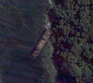
The small Madagascar island of Nosy Mangabe (where many of the Aye-Aye Lemurs live) is also available in pretty good definition. Note the ship on the western side of the island. I wonder if this is a wreck?
Technorati Tags: Google Earth Google Maps
7 comments:
You can look at the KLM file in your browser using Google Maps here
Yes thanks. I did initally have a different version that had Image Overlays, but thanks to some welcome advice from Frank at the Google Earth Blog, I changed them to custom icons, so the other Maps version isn't really necessary any longer. The KMZ works just as you say.
Hi,
thanks for providing these location points. It's fun to listen to Mr Adams while exploring the places he went.
But I think the "Northern White Rhino (DR Congo)" is in the wrong place.
At the moment it's located at
1° 1'52.62"S
22°15'11.75"E
which of course is in the Democratic Republic of Congo. But as it is reported that the last few (two?) rhinos are in the Garamba National Park in the northeast of DRC and Mr Adams took the journey there it would be better to place the rhinos at:
4° 0′ 0″ N
29° 15′ 0″ E
so the park would be hit:-)
Source:
http://whc.unesco.org/en/list/136
(the coordinates are given there)
Thanks Joerg. When I get a little bit of time I'll make the adjustment you suggest.
Hi,
It's a shipwreck alright. Allegedly it was left there by one of Madagascar's former presidents. There's a
close up photo on my website.
Regards, Dylan
Sorry, i linked to the thumbnail. Maybe you can correct the link in my previous entry..sorry for messing up
the link should have been:
http://8thcontinent.nl/gallery2/main.php?g2_itemId=453
Post a Comment